River Trip
The Thames in Inner London
Before 1900 only the 'City of London' was referred to as 'London'. The City of London is situated on the north side of the Thames, linked to the south bank by today's five bridges - Blackfriars Bridge, Millennium Bridge, Southwark Bridge, London Bridge and Tower Bridge - as well as two railway bridges - Blackfriars Railway Bridge and Cannon Street Railway Bridge.
Land not within the City of London boundary was (on the north side of the Thames) in the County of Middlesex or the County of Essex. South of the river, the land was either in the County of Surrey or the County of Kent.
Metropolitan London
In 1900 the 'County of London' was created, administered by the London County Council (LCC). The new 'county' was formed from parts of the old counties of Middlesex, Surrey and Kent. The whole area was sub-divided into 28 Metropolitan Boroughs, in addition to the original City of London.
Greater London
In 1965 a new administration came into being, called the Great London Council (GLC). The area covered was the old Metropolitan London with another 'outer band' added to it. The 28 Metropolitan Boroughs were combined to form 12 new administrations, now called Inner London Boroughs (like Lewisham, Camden and Tower Hamlets). Around the Inner London Boroughs another 20 Outer London Boroughs were formed (like Newham, Brent, Croydon, Bromley and Bexley) making a total of 32 Greater London Boroughs as well as the separate administration of the City of London.
The Thames in Inner London
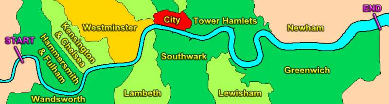
The stretch of the river covered in this Website extends from Hammersmith, in the west, to Woolwich, Plumstead and Thamesmead in the east. The river passes five London Boroughs on the north bank and another five to the south, as shown on the map above. In addition, of course, it also flows past the City of London (shown in red).
A River Trip, Divided into Sections
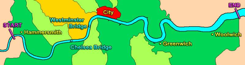
To avoid very long page lengths, the description is divided up into sections (named in BLUE on the above map). Links at the bottom of this page will take you to each section. The journey will take us from Hammersmith, via London Bridge, all the way downriver to the Thames Barrier and the Woolwich Ferry.
Information describing the places of interest beside the Thames is divided into TWO columns with the river itself being imagined as running down the centre of each page. To the LEFT, places on the SOUTH BANK are listed. To the RIGHT are places on the
NORTH BANK. The text will be interrupted by the many bridges and tunnels crossing
the river.
Starting on the next page, the top of the page represents the location of Hammersmith. The foot of the last page represents the site of the Woolwich Ferry and a few places further east. Now, sit back and relax, and read through the description of the main places of interest.