To anyone who remembers the old docks or even worked there, 'Surrey Docks' was what everybody called them. Their official name was 'Surrey Commercial Docks'. The name derived from the fact that they were the only docks ever constructed on the south side of the Thames which was originally in the County of Surrey. The other word in the name - Commercial - derived from the fact that the docks were the combination of smaller companies, each one running one dock. One of the larger companies was the 'Commercial Dock Company'.
The Port of London Authority (PLA) came into existence in 1909, bringing all dock companies under one large administration. At that time, the Surrey Commercial Docks were a the large expanse of land, consisting of a collection of no less than eleven docks. The commodity for which the docks were most famous was timber.

Surrey Docks - 1868 - Bacon's Map
The Thumbnail is shown 4% of original size (because it is so large). All the other thumbnails are shown 10% of original size. PLEASE NOTE: The 1868 map is a large file and it may be rather slow downloading if your Internet is slow.
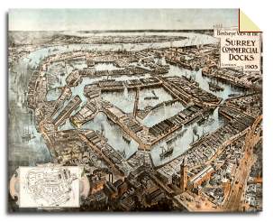
Surrey Docks - 1905 - Timber Trades Journal
This unusual drawing looks east from an imaginary point high above the old Docks Office which is shown, with its tall clock tower, near the lower edge of the picture, not far from Lower Road which is the bottom right-hand corner.
The Thames runs along the left-hand side. The picture also shows the Isle of Dogs on the horizon. The drawing was made for readers of the 'Timber Trades Journal'.
One fascinating feature of the drawing is that. although steam tugs and steam ships are shown, the artist included sailing ships, of which three are shown in Greenland Dock (the large long dock, running NW-SE near the top right of the picture).
Surrey Docks - 1908 - Bartholomew's Map
The docks are all labelled with names that survived until they were closed in the 1970s and, in some cases remain in existence today. Notice too that Surrey Quays Overground Station, which was called 'Surrey Docks' before it was renamed in the 1980s, is shown with its original name of 'Deptford Road Station'.
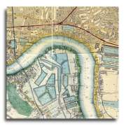
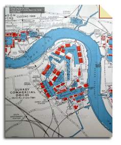
Surrey Docks - 1966 - PLA Docks
In the days when the docks were in use, ships captains arriving in London did not always know where each individual dock was situated within a particular dock system. Similarly, if a lorry-driver had a load of goods to pick up or deliver, he needed to know where each warehouse was positioned within a dock system. The Port of London Authority (PLA) produced a simple free map of all the docks giving this information. It showed each individual dock, clearly named, along with the name or number of each warehouse standing near it.
This map shows the part of the map relating to the Surrey Docks. It may have been the last time that they were shown in their entirety because, within about five years of this version being printed, the docks were officially closed. Notice also the Grand Surrey Canal, shown running south from Greenland Dock, which closed about 1971 and gradually fell into disrepair.
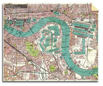
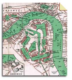
Surrey Docks - 1966 - Wharf Map
Such a map, in papaer form, is rare today because it is no longer printed. Every few years a new edition was published, showing an alterations to the wharf names or the position of the docks. The last edition was published in 1966 and the map was available until stocks ran out some time in the 1970s.
The map also carries information that only thise who worked in the docks would know about - the names or numbers of the sheds that lined the dock-sides. To anyone who worked in the Surrey Docks, this map is a 'step back in time'.
Surrey Docks - 1970 - Docklands
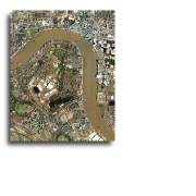
Surrey Docks - 2004 - Aerial
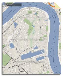
Surrey Docks - 2012 - Modern Street Map
By the 1970s the Surrey Docks were already closed, although many warehouses continued to be used as storage depots. In 1980 the London Docklands Development Corporation (LDDC) came into existence. Since, by that date, many of the docks had lost all their water, it was impossible to reinstate them.
Of the original eleven docks, only two docks and one basin remain in their original state: Surrey Basin, now called Surrey Water, remains - now used as an amenity. Greenland Dock remains - now used for water sports. South Dock remains - now in use as a marina. The NW end of Canada Dock remains, now called Canada Water - landscaped as a water feature.
Norway Dock, now only about two feet deep, has been redeveloped as a housing estate. A small part of Lavender Pond remains, at the northern end, landscaped as a nature park.